Bringing ancient and modern technologies together in Alaska
As I embarked on my inaugural semester at Adelphi, I was thrilled to be sharing my research with students on the prehistory of Alaska. After all, archaeology is fascinating and will practically “sell” itself, right? But how can an archaeologist, steeped in the antiquated world of yester-millennia, offer an interesting and engaging curriculum relevant to the tech-savvy 20-something student of today? Good question, and one I’ve pondered since joining the anthropology department last fall.
Immediately, I realized not everyone spends as much time contemplating the ancients as I do. Talk about outdated—the basis of my work often entails such relatively mundane events of the past as sharpening a knife, making a campfire or stalking a woolly mammoth in distant and cold lands. No wonder students spent more time texting and tweeting than reading my arcane assignments. As a specialist in ancient stone-based technologies half a world away, it occurred to me that my work might actually have little in common with the suburbanite students of New York.
I needed a new and exciting pedagogy if I was to convey the adventurous world of archaeological inquiry to 21st-century students. Luckily, I had grown up in the computer age, done my undergraduate work with the newly formed Internet and had even sent an email or two in my formative years. Combined with a working knowledge of the co-evolution of humans and technology, I had a few useful qualities on which to develop a truly experiential learning and research program at Adelphi.
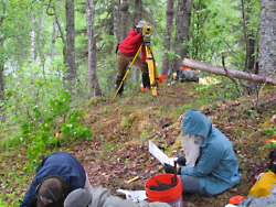
Students taking notes and mapping using an electronic theodolite (ELT).
Because many archaeologists are specialists in technology, we tend to incorporate the latest available gadgetry, including computers and other devices, into our pursuit of the past. For my students, this involves Global Positioning Systems (GPS), an electronic theodolite (ELT) and sophisticated software such as geographic information systems (GIS) to map and analyze landscapes and patterns much as a high-tech crime scene investigator might do. Along with a good mystery, students also love gadgets with tiny screens and buttons they can push. But what are these systems and how are they relevant to students preparing for a modern economy?
According to the Environmental Systems Research Institute, GIS combines static media,such as paper maps, atlases and landscape photography with databases in a dynamic analytical software environment. GPS units are more familiar to us as satellite-based guidance systems. While GPS units only recently joined our collective bag of techie toys, they originated as classified instruments of war. Archaeologists began using them in the mid 1990s to pinpoint artifact finds, and that’s precisely where I was first exposed to GPS as a student on an archaeological field school. Today research-oriented GPS units combine GIS capabilities to collect data and navigate in the field. For more precise mapping projects we use a laser-based ELT to document and reconstruct site context back in the lab.
Putting archaeology aside, some of these technologies are widely utilized in many professions, from political science to the Center for Disease Control, civil engineering to system economics, and employers in both private and public sectors are increasingly reliant on new hires with GIS or GPS experience.
Student texting “in class” from the remote Trapper Creek Overlook site in southern Alaska.
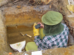
For these reasons, the Adelphi Archaeological Field School in Alaska program was conceived. What better way to persuade students to stop texting and start thinking than to put a trowel in one hand and a GPS unit in the other only to send them forth into uncharted territory with no more than a backpack and a question? Designed as a peaceful haven, free of distractions or even plumbing, for that matter, this was a class where students could embrace the natural environment and local cultures as well as use advanced tools in an actual research setting.
Our first program was a four-week expedition to a forested region near the quaint mountain community of Talkeetna. Ten students completed the course and gained a greater appreciation of modern and ancient technologies alike. They also thoroughly enjoyed the wilderness experience and in particular using Adephi’s advanced technology. Students navigated the featureless forest using only handheld instruments and took precise notes mapping ancient archaeological evidence. The combination of advanced technology, rugged wilderness and learning field methods influences students in unforeseen ways.
Back on campus, it’s one thing to explain the importance of these technologies in the classroom or laboratory, and on occasion I may even send students across campus in search of a vague waypoint or two, but it is really the summer field program that has been critical in their learning. Taking inquisitive and adventurous students into a pristine frontier and providing them a truly active role in multidisciplinary research has proven transformative on a variety of levels.
Looking back on our first Adelphi program in 2011, I learned a few things as well. While GPS units can be fun and engaging, there is no substitute for a student’s cell phone, and they quickly realize that texting is still possible even in this far-off land.
For more on the Adelphi Archaeology Field School in Alaska visit https://academics.adelphi.edu/artsci/ant/research.php.

For further information, please contact:
Todd Wilson
Strategic Communications Director
p – 516.237.8634
e – twilson@adelphi.edu